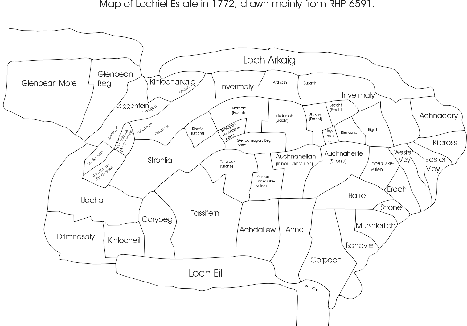
This is a very useful simplification of Morison’s 1772 map but I have a doubt about one small aspect and that is at the eastern end of Invermaly (now Inver Mallie on OS maps) you have labelled an area as named “Regall” and I was wondering on what basis you have done so? In my own research into my 5-greats grandfather – Alexander Cameron, 1737-1832 – 5th and last Tacksman of Invermallie) I have included this area as part of Invermallie as it does not mention any acreage whereas the one to the west of it does. From Morison’s farm maps and specifically his ?1774 map of ‘Part of Innermaly’, what you have labelled as “Regall” seems to be part of Alexander’s farm? On this farm plan the acreage is quoted as being 6043 – clearly much larger than the farm area and the significance of this map for me is that it is the only one showing the full extent of Invermallie. I look forward to your comments on my interpretation to date. Regards and thanks, Roger Cameron
Roger, Thank you. My apologies for the delay but I had to dig out my old notes.
My placing of Rigall derives from an entry in a typescript copy of the ‘Report of the Contents and Estimate Rents of part of the Annexed Estate of Lochiel, 1772, by William Morrison’ – which MS is in the possession of Lochiel. The copy was made by Dr Chris Robinson in 1988 – in an edition of 30. One copy was deposited in Fort William Library and that was the version I studied.
There is a composite plan in National Archives of Scotland under RHP 22822 and another under RHP 6591. There is also one in the West Highland Museum, Fort William.
Page 39 of the typescript copy deals with Rigall. It is described as a shieling of 791 acres but included 18 acres, 2 roods of arable. There are a number of farms, in Lochaber and elsewhere, where such was the pressure on land in the eighteenth century that shielings were taken in for permanent cultivation – rather than just being used for grazing in the summer. In the nineteenth and twentieth centuries these were often abandoned again and the land reverted to rough grazing. This may lie behind the apparent anomaly. Strictly speaking, Rigall was a shieling – perhaps temporarily elevated in status to a farm.
Its location is described in the text but there is difficulty in placing this exactly on the ground. Not all the place-names given in 1772 are now identifiable. However, it had Inver Mallie to east and a shieling called Rienaund to the west. Rienaund is located on RHP 6591 and its text entry tells us it was bounded on the east by Rigall – which belonged to Easter Moy. That is why I have placed Rigall where it is on my map. If I had to locate it on the modern map I would suggest it lay on the south side of the River Mallie in NGR squares NN1288/1388/1287/1387. Neither Rigall nor Rienaund originally belonged to Inver Mallie.
Hello Sir, I was intrigued and proud to read your comments, I too am a Cameron who still resides in Scotland,it’s fascinating to know all these relatives are out there, I haven’t yet done all my research, my Grandfather was called Alexander Cameron,my father is Alexander Mcdonald Cameron, my name is Scott Alexander Cameron and my son is Euan Alexander Mcdonald Cameron, as you might have guessed I’m a very proud Cameron and look forward to doing my own research, I just wanted to introduce myself & say hi from a fellow kinsman, Good luck and God bless
Dear Scott,
Thank you for your kind comments. I recommend the West Highland Museum in Fort William. Lots of Cameron material there!
Best wishes
Denis